- REVIEWS
Camera Reviews 
More Reviews Mobile Reviews Photography Reviews - GALLERIES
- VIDEOS
- BUYER'S GUIDES
Microsoft’s Pro Photo Tools 2; A Post-Exposure GPS Program Page 2
 |
|
|
Of course, if you do have metatag data for the location saved as a track route, you can load those coordinates and use them for the GPS data. The idea here is that you use a GPS device at a photo shoot, save the track route as a file, copy the file to your computer, and then manually match up that data to the images. I actually preferred just using the map feature, which is a testament to how simple it is to use and how precise it can be about shoot location data. It made me wonder whether, with this tool, a GPS chip inside a D-SLR was really necessary as Pro Photo Tools 2 becomes part of a workflow.
Advanced Features
As a metatagging program, Pro Photo Tools 2 lets you add even more data to images. There are several “tasks” available. You can add a bevy of descriptive data, including a title, description, rating, keywords, and copyright notice. You can also manually enter the exact time and date for each photo. Pro Photo Tools 2 includes an option where you can duplicate time and date for the IPTC metadata field.
You can further tag images in the “Others” section with a photo credit, usage terms, and the names of people in the photo. Like the GPS coordinates data, each of these metadata fields are batch processed—they can apply to all select images. You can review shot data for images, such as width, height, whether a flash was used, and the ISO setting. For adding GPS coordinates, these extra fields are helpful because you are essentially adding location data and matching it to all of the other metadata. For example, you can link the fact that you shot in ISO 200 for a series of outdoor shots in San Jose and keep track of all the fine details—not just for the foreseeable future, but for long-term archival.
 |
|
|
Raw support in Pro Photo Tools 2 doesn’t work quite the same way as it does in, say, Lightroom 2. The program does not natively support raw, but you can download the codec for your camera, install it in Windows Vista, and then Vista will process the raw data automatically when you open images in Pro Photo Tools 2. For example, you can download the Canon codec at: www.canon.com/support-hub/rawcodec. Pro Photo Tools 2 does a good job of helping you find raw codecs. At the Microsoft support site, there’s a link (www.microsoft.com/prophoto/downloads/codecs.aspx) for finding your camera’s codec.
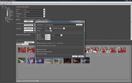
Pro Photo Tools 2 also allows you to export images in JPEG or TIFF, adjust the image resolution, and decide whether to include all metadata, just the copyright, or a subset of metadata without GPS coordinates. The expert features are handy because you can use a single program in your workflow for processing all images, re-sizing them, and preparing them for long-term archival or for a client. In the end, it means you could skip a photo browser like Windows Vista Photo Gallery altogether if you know you just need to track metadata and not actually perform any post-processing adjustments to the images.
 |
|
|
Pro Photo Tools 2 is a powerful location-tracking product, and since it’s a free download (www.microsoft.com/prophoto), I highly recommend it for anyone who needs to know the who, what, and where of photography.
|
| |||||||||
- Log in or register to post comments


![]()
Get the Latest Photo Tips, News & Reviews from Shutterbug!
| Camera Reviews Other Reviews | Mobile Reviews Photography Reviews Columns | News | Features | How-To | Resources |
 © 2025 Shutterbug
AVTech Media Americas Inc., USA
All rights reserved