- REVIEWS
Camera Reviews 
More Reviews Mobile Reviews Photography Reviews - GALLERIES
- VIDEOS
- BUYER'S GUIDES
Black Hills, SD: Driving Or Hiking, Great Photo Ops
All Photos © Clint Farlinger
The Black Hills of western South Dakota, rising as an island of trees in a sea of grass, are home to Mount Rushmore National Memorial, Wind Cave National Park, Black Hills National Forest, Custer State Park, Harney Peak (the highest peak east of the Rockies), and arguably the best photo opportunities in the Midwest. Singularly, any of these places are wonderful to photograph, but considering all these special areas are within an hour’s drive of each other, the Black Hills are a premiere photo destination.
An extension of the Rocky Mountain uplift, the 6000 square miles of rugged valleys and hills have a long history with the Lakota and Cheyenne peoples, who called the sacred hills Pahá Sápa and Mo’ohta-vo’honáaeva respectively. The English “Black Hills” comes from the Lakota “Pahá Sápa,” which roughly translates as sacred mountains emerging from the earth that appear dark when seen from a distance. The dark appearance is caused by thick forests of Ponderosa pine and Black Hills spruce that cover the hills, and they are visible for quite a long distance because they rise rather abruptly from the surrounding plains.

I prefer to strap my camera on my back and see nature from the trail, and with over 500 miles of trails, the Black Hills are a prime locale. However, the Black Hills are also driver friendly, and much can be photographed near the road. Maps of the area are available at rest areas along Interstate 90 as well as many hotels, restaurants, gift shops, etc. These one-page maps are indispensable, and include both the most direct routes between destinations and more scenic alternatives. The Needles Highway, which passes awe-inspiring granite spires, and Iron Mountain Road, with pigtail bridges and unique views of Mount Rushmore, are part of the Peter Norbeck Scenic Byway. Sharp curves, narrow tunnels, and steep grades punctuate this incredibly scenic byway. Further west, the Spearfish Canyon Scenic Byway leads into the scenic canyon where much of the Academy Award-winning movie Dances With Wolves was filmed. Here are a few of my favorite locations to visit, explore, and photograph.

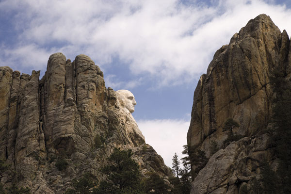
Mount Rushmore National Memorial is a must-see while in the Black Hills. The monument faces mostly east, so morning is the best time for photographing in natural light. However, each night during the summer, the Park Service holds a lighting ceremony, and this is absolutely my favorite time to photograph the world-famous faces. I often include some or all of the Avenue of Flags as the foreground, which means other visitors are walking through my frame. The good news here is that the exposures are so long that if the people in the frame keep moving, they don’t appear in the final photo! Take a lot of exposures and there will usually be a few that look empty. Another fun photo is from the parking area south of the memorial, looking up at Washington’s profile.
The main attractions at Wind Cave National Park and Jewel Cave National Monument are, well, the caves. While the challenges of cave photography are beyond the scope of this article (see the January, 2008, issue of Shutterbug for a discussion on photographing caves), both offer aboveground opportunities as well. The area above Wind Cave is native grasslands with free-range bison. The Red Valley area is an easy drive on graveled roads to a scenic open area. Hike the Boland Ridge Trail for splendid views of rolling hills with red dirt adding color here and there. Newborn bison and the green grasses of early summer make late May and early June my favorite time to visit.
Historically, Jewel Cave has been covered by Ponderosa pine forests, some of it old growth, but over 90 percent of the park was burned in a wildfire a few years ago. A park ranger stated that this has led to an abundance of wildflowers, but I haven’t had the opportunity to experience the bloom firsthand.
Custer State Park is one of the premier state parks in America. The Needles Highway was meticulously designed and routed to take travelers past incredible scenery such as the Cathedral Spires and Sylvan Lake. The trailheads to Little Devils Tower and Harney Peak begin in the Sylvan Lake area. Both of these trails are steep and difficult, but lead through beautiful forests to unparalleled views of granite spires and rugged hills. At 7242 feet, Harney Peak is the highest point east of the Rocky Mountains, and offers splendid views of the Black Hills.
Several shorter trails can also be found on this end of the park. The Sunday Gulch Trail, located behind the spillway of Sylvan Lake, and the Cathedral Spires Trail, located at the Cathedral Spires parking lot, are both shorter, easier trails and definitely worth exploring.
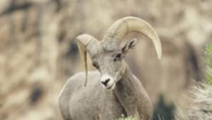
In contrast, the southern end of Custer State Park is open and rolling, similar to the terrain found at Wind Cave. The 18-mile Wildlife Loop Road circles this area and gives visitors the chance to observe bison, pronghorn, elk, deer, and prairie dogs. Early morning and late evening are the best times to see and photograph these animals. It’s usually not difficult to find the bison herd and see a few pronghorn, but the elk are more elusive and truly a treat if you find them. Each fall the park holds a bison roundup, attracting hundreds of spectators and providing opportunities to photograph cowboys hard at work.
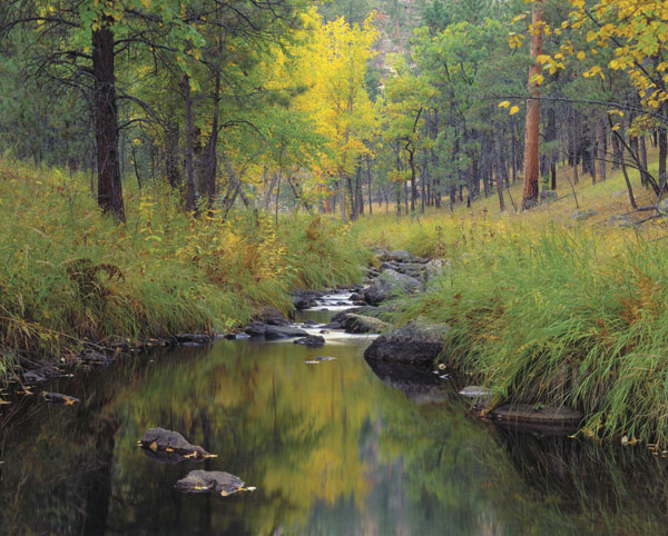
Black Hills National Forest covers over 1.5 million acres, with photographic highlights including Harney Peak, Black Elk Wilderness, and Spearfish Canyon. As discussed earlier, my preferred (e.g., shortest) route to Harney Peak starts in Custer State Park, even though it passes into the National Forest and through part of the Black Elk Wilderness. Another nice hike in the Black Elk Wilderness is the Horsethief Lake Trail, which traverses through the Wilderness and onto Mount Rushmore. The first half mile or so from the Horsethief Lake trailhead follows a small creek as it cascades down moss-covered granite boulders. Also in the same vicinity is the Willow Creek Loop Trail, which passes through a particularly beautiful Ponderosa pine forest and offers a scenic vista of distant peaks.
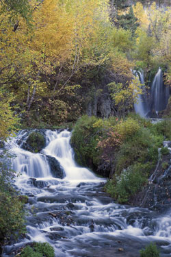
Spearfish Canyon is another gem whose beauty words cannot describe. Bridal Veil Falls and Roughlock Falls have easy access and are best visited in the spring when flowing water is abundant. I’ve been lucky enough to visit during a wet autumn, and the combination of the waterfalls and autumn foliage was spectacular. An easy walk along Iron Creek leads to cascades over boulders and around sheer cliffs. Little Spearfish and Rimrock Trails offer longer hikes through the rugged terrain, but simply walking part of the trails shows many of the canyon’s secrets.
To see more of Clint Farlinger’s photography, visit www.agpix.com/farlinger.


![]()
Get the Latest Photo Tips, News & Reviews from Shutterbug!
| Camera Reviews Other Reviews | Mobile Reviews Photography Reviews Columns | News | Features | How-To | Resources |
 © 2026 Shutterbug
AVTech Media Americas Inc., USA
All rights reserved